
February 11 - Stats: 8.7 km / 608m gain / 1407m high
A play of light and colors filled the sky as we headed for Pump 1 to watch the sunset over the city and harbour of Vancouver.


The first stretch followed alongside the downhill ski slopes. This heavily used route did not require snowshoes. Micro-spikes would suffice.

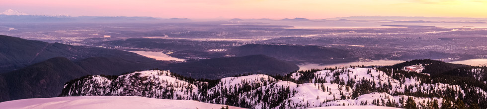
Looking south at Vancouver's harbour and Vancouver Island.

Southeast. We could see Mt. Rainier in the hazy distance.

West towards Cypress Mt.

North.

Southeast -- Mt. Baker

Steeps uphill slopes included some shorter steep downhill sections. We were in no hurry as we'd arrived with about 45 minutes to spare. We wanted to keep lingering at the summit to a minimum because of the cold. But as you can see, we were stripped down to our shirts during the ascent.


Passing through a gully, far enough away from the avalanche slope and lined by old growth douglas firs.


Northeast.

A no-go zone.

Indian Arm down below.

Passing through the valley of the "snow" dunes.

Of course Cal had to jump this cornice.

But I don't think he counted on continuing to slide quite so fast nor so far, zooming right between and past us.

Our destination in sight: Pump 1.

The Fraser River -- southeast.


Ascending Pump 1 was rather intimidating. Its very steep, especially just before the very top.


North.

The second pump to the left -- north.

Hungry hikers settled in to wait for the 5:20pm sunset.


Group shot: Herb, Michelle, Maureen, Mark, Irene, Brian, Denise, Brigette, Don, me, Cal.


Southeast to south.


Notice the tent to the right. There were a few of them, settling in for the night. Fortunately it was not windy.

Heading back down.


Comments