
Hozameen Mt backpack
- Jocelyn Timmermans

- Sep 28, 2021
- 3 min read
Sept. 24 - 26: The riot of bold and beautiful autumn colors in the alpines were a feast for the eyes. Four of us strapped on our heavy backpacks (35 lbs for me) and began our 3-day adventure...
Day 1: 14 km / 810m elevation gain / 1950m high point
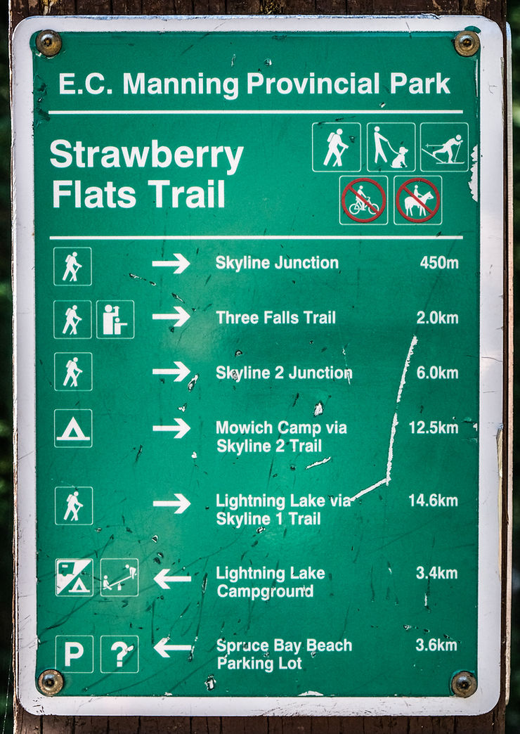
We stared at ended the hike at Strawberry Flats. Camp Mowich was our destination for the first day.

The trail was in very good condition and had a nice gradual grade.


And voila! This is what I was so excited about seeing. And I was not disappointed.


Almost at the junction on the Skyline trail. We got our first glimpses of the Hozameens to our right -- southwest.

Snowcamp, Goat & Red Mts -- west. Snowcamp is a nice destination for a day trip.


At the junction, 6 km in and halfway to Mowich camp -- south.

The valley where the chain of lakes are nestled in. Lightening, Flash & Strike are pretty close together but Thunder is about an hour's hike from Strike. Thunder is the one we could view from the ridge.

We turned from south to west, following the ridge. Hozameen (2164m), Snowcamp (1920m) & Lone Goat (1890m) Mtns.

The junction was an ideal spot to have lunch.

From the junction we dropped over 100m back into the forest.

And then gradually climbed back up towards the open alpine ridge.

Almost up on the ridge and soaking up views galore.

Mt. Frosty (2310m) -- east.

Thunder Lake under Lone Mt (1740m) -- south.


Southwest -- the prominent Hozameens.

Lone Goat Mt. The trail wrapped round the left of it before making the final descent to camp. At it's highest point, it couldn't have been much more than 100m below the peak.

Red Mt (1950m) -- north.


east

Frosty (2310m), Castle (2408m), Freezeout (2256m) + Joker (2256m) Mts -- south.

Looking back at Snowcamp Mt.

west

A viewpoint before turning round the bend to the right and beginning the gradual descent to camp.


Day 2: Stats: to lookout and end of trail: 11.7 km / 700m gain / 1950m high


To bed at dusk meant a long night in the sack. But we all slept good and woke at the crack of dawn.

Girl power.


1) Fresh bear footprints by the creek. 2) Adjusting the backpack.


Once we were on the ridge there were mellow ups and downs (till the last slope). We had views on either sides.


Red, Lone Goat + Snowcamp peaks -- northeast.

Destination in sight.


Yup, we had to climb up that steep slope. But the lookout was just beyond it.

Ooo eee. Couldn't get enough of these colors.


Looking down.

Made it. Views from the lookout.

Ross Lake below Redoubt Mt (2499m) -- west.

Four years ago I was here and really wanted to drop down to the border and explore. Thankfully Michelle was game. We had to be very careful on these steep scree sections.

Monument 74. We were naughty and crossed the border into the US. No helicopters, no problem.

We didn't go far into the US. But I wanted to see if we could access the ridge on the right. And we discovered we could. The trail petered out here. So we plan to climb it next time we're out there, getting an earlier start and getting closer to those imposing peaks. We can also get to the meadows from that ridge.

We carefully climbed back up the loose scree, marked with occasional cairns, to the lookout at the top of this slope. This little add-on excursion took about 40 minutes (and are not included in the stats).

Heading back and looking at Mt. Frosty, Castle & Freezeout Peaks -- east.


Looking back and up at Terry descending my favorite slope.

Back at camp. I got my very own campsite. The first night there were only 2 other girls there and the second night 3 other men who stayed at the other end of the meadow which also has a fire-pit and log benches.

Day 3

I was hoping it wouldn't rain in the night, as the forecast was for clouds and showers. I didn't expect to wake to blue skies, sunshine and a dry tent.

We started the gradual climb to the ridge just after 9:00am.

Redoubt Mt -- west


Morning light.

Snowcamp Mt.


Thunder Lake.


Heading up towards Snowcamp's rounded peak.


Looking back at the ridge we'd walked on the day before. The lookout is on top of that hump to the left (right of the Hozameen peaks).


Red Mt, living up to it's name.

Almost at the Skyline junction where the trail leads to the edge of the cliff.


After the junction and back in the forest, the clouds started to close in. But it didn't rain till we started driving home mid afternoon. We were thankful to have been so fortunate with the weather.


None of us had ever seen this mushroom before.


Comments