
HBC trail - mid section; Podunk Creek
- Jocelyn Timmermans
- Sep 1, 2021
- 5 min read
Updated: Sep 7, 2021
August 24 - 26, 2021
The HBC 1849 Heritage Trail was originally a First Nations route for hunting and trade. The Hudson's Bay Co. adopted the route in the 1850s when brigades of up to 200 horses and dozens of men would travel the trail each season, bringing valuable furs to the coast in spring and returning inland in the late summer to resupply forts in the interior and far north.
This was the third section of the trail that I completed, thus doing the first 40km minus the 10km section from Fool's Pass to Sowaqua Creek FSR. So that'd be 80 km because they were done as out-and-back day trips. The first section was Mansons Ridge and the second was Palmers Pond (so titled in my blogs).

Day 1: Tulameen Falls -- We left at noon on the 3.5 hour drive. My hopes fell when we got to the Britton Creek #228 turn off on the Coquihalla Hwy and a large sign read: ROAD CLOSED. But we weren't so easy to discourage, and there was ample room to drive around the sign. There were no further signs on the FSRs to we kept going on the Tulameen FSR for 30.2 km to the Tulameen Falls.

These slopes were bursting with pink from all the Fireweed. We did not encounter any logging trucks and the road was in good shape, other than a few washer-board sections.


Look for this tree by a pull-out in the road. At the tail-end of a hot dry summer, the river was
easy to cross.

This trail is 2km-return, and 76m gain x 2 (it drops down, only to climb back up to the falls).


The water was surprisingly warm and would've been great for a dip.


Case did not bring his water sandles so he could not cross the river by the falls since it was almost knee high.


The beginnings of autumn.
After driving the Tulameen FSR for 45 km, we arrived at Jacobson Lake camp (1477m). Temperatures dropped to near freezing at night.

Glad I didn't forget my water filter. This lake was shallow and murky.


Day 2: Palmers Pond + subpeak of Mt. Davis
Stats: 15 km / 977m gain (700m to summit) / 1956m high / 6 hours MT

We went to bed early (9:30pm) and rose with the sun (6:00am).

500m down the path from the campsite, we got to this sign on the HBC trail and turned right.


The views opened up by Conglomerate Flats camp. Mt. Davis is the peak to the left.

1 km farther west got us to Palmers Pond.

Indian Paintbrush + Asters


A thin arm of rock holds Palmers Pond on the edge of a cliff. Tulameen Mt. to the left.

Standing on that thin-arm-at-the-edge-of-the-cliff.

Still morning reflections.

The year before we'd been here and tried to find the trail to Mt. Davis, having come up from the west side. Coming from the east is not near as steep.

east

Just at the crest of the slope west of Palmers Pond, we turned left onto a faded trail and soon came to a junction where we turned left again.

There were sections where the trail was so faint we sort of had to guess where to go. Obviously not an often used trail.

Mt. Hatfield so named after Harley Hatfield who played a leading role in restoring the HBC trail from Hope to Lodestone Lake in 1967 -- southwest.

There were only 2 cairns and a few faded flagging tapes to mark the way. So bring your GPS!

We followed a trail along the west side of this sister peak of Mt. Davis. The trail abruptly ended so we bushwhacked the last little bit. Once on top we had wonderful views. This peak is only 57m lower than Mt. Davis (2012m).

Looking south across the valley at Mt. Outram. Just four days prior we were on the top of it (2460m).

Tulameen Mt (2190m) -- north.

East towards the rolling hills of the interior.

We backtracked to the meadow and then climbed up the talus slope to a flat area on the northeast side of the sister peak.

Upon closer inspection, we estimated that it'd take another hour to summit Mt. Davis and the rock cliff section looked sketchy. I should've downloaded a route at home. Now I wasn't sure if this was the way to summit it. We decided to be content with the peak we'd been on, knowing the views wouldn't be much different. Once back at home I determined that this was indeed the best route to the summit.

Mt. Outram, Manson Ridge + Hatfield Mt. (1726m).

Heading back down.


Case wanted a swim in Palmers Pond. He didn't last long in the frigid water. But he said, "It was quite refreshing!"


East.

In the meadows, approaching Conglomerate Flats camp.


Case says this spruce is about 1000 years old!


Back at Jacobson Lake camp. We took our FJ but it wasn't really necessary. A 2WD would've been fine on the Tulameen FSR.

Had to keep Case occupied. It was too early yet to play games. So he filtered water and picked blueberries. They were nice and sweet and abundant.

The grey line starting from right to left shows the route we hiked. Notice we almost did a complete loop on the sister peak.
Day 3: Podunk Creek -- Stats: 25 km / 880m gain / 1470m high point / 8.5 hours MT
A big thanks to Hope Mountain Centre for clearing this stretch of trail just weeks before. Case estimates they did about 300 cuts. Alot of work!
This piece of trail remained in the forest all day, only opening up a bit at Horsegaurd camp.The trail runs parallel with Podunk Creek. But so does the Tulameen FSR, on the other side. My logical brain thinks, "Why hike it when you can drive it?" But then I couldn't have knocked it off in the "105 Hikes in SW BC" book and we wouldn't have seen all those monster mushrooms and families of grouse.

Case has a size 12 foot.


Notice the end of Case's hiking pole (just to get a sense of perspective).

We were on the trail at 6:30am.


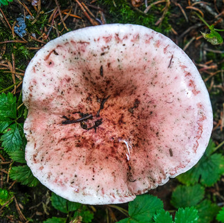
These mushrooms were the size of dinner plates.

Freshly cut trees to clear the way.

There were about 8 grouse here.


Then came the male, protectively checking out what all the commotion was about.

Having done the Dewdney trail a few years ago, it was interesting to see where this Whitecloud Lake trail came from and how it was connected.


This wood-wart was the size of a basketball.

Although the trail ran alongside the creek, we were too high above it with too much brush between, to make it possible to fill our water bottles from it. But there were several creeks along the way.


The final stretch of trail before Horseguard campsite was a steep 90m drop.


At the 40 km mark on the 74 km long trail.


Had a nice long break here.

Yes, this is the way to cross the Tulameen River if you don't want to take your boots off to get to the trail on the other side. This tree was attached to cables on either end.


Heading back.


Neat how these leaves grew right through the mushroom.


Case kissed the toad. Bear or cougar?


Comments