
Extension Ridge + Mt. Benson
- Jocelyn Timmermans
- Nov 23, 2023
- 3 min read
Updated: Nov 27, 2023
Nov. 16, 2023 - Nanaimo
After our 4x4 drive to Carmanah Walbran PP, we drove back to the east side of the island and stayed the night at the Oceanfront Suites in Cowichan Bay. Our friends had just been there and highly recommended it. Sure enough, the steller sea lions were there on the docks.

One glimpse outside and I was rushing to put my clothes on, grab my zoom lens and get out there.

In the elevator of the resort there was a sign that read: "They're back! Complimentary earplugs available at the front desk."


This one had an itch.


Case stealing apples by the roadside from someone's yard.
Extension Ridge is a part of the TCT trail, the longest trail network in the world.
Stats: 10 km / 454m gain / 276m high point / 3 hours MT
Last December Case & I started out on this hike, but did not complete it. A wrong turn cost us precious time that we didn't have to spare because we had to catch the ferry. This time we parked at the second parking lot, northwest of Colliery Dam Park on Harewood Mines Rd by the kiosk, having done the 35-minute stretch from the first parking lot in Dec. 2022.
Extension Ridge sits on the edge of a mined-out Nanaimo coalfield.

At the Abyss fissure. Arlene (my sister-in-law) is telling us a friend's little dog fell in this crack.


A forest of Arbutus, Douglas Fir & Gary Oak trees.


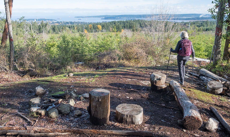
Two chairs carved out of stumps offered a lovely view to the east. This is where we turned back last time.


A Manzanita shrub.

A stone circle.


A view to the west.


In December we had no view due to bad weather. Now we could see the city of Nanaimo, Newcastle, Snake & Gabriola Islands and the mainland.


At the road and end of Extension Ridge, we took a different trail back for the first bit along the ridge.
We spent the night at my brother, Rick and his wife, Arlene's place. Arlene gave us the pleasure of her company on our two hikes.
Mt. Benson
Nov. 17 - Nanaimo
Stats: 10 km / 930m gain / 1079m high / 4 hours MT
The start to this trail was rather confusing. In the Destination Hikes book it states: "from the Kiosk, head through the yellow gate and take the floating bridge over Witchcraft Lake." But there was no yellow gate by the kiosk and no floating bridge, just a short wooden bridge over a creek. We ended up walking the full length of Witchcraft Lake without finding a floating bridge.

Mirror reflections in Witchcraft Lake.

We had to backtrack a bit on level ground to get to the Mt. Benson trailhead. From there it was up, up, up.

The first viewpoint on a rocky bluff, overlooking Naniamo.


The trail was steep, rocky & rooty. We turned left at marker 30, but had no view thanks to low lying clouds.

A rare phenomenon: Feather Frost which usually grows on a piece of dead water-logged wood.


About halfway up we crossed the Old Rail Trail and were then on the Straight to the Top Trail.

An open section provided a third viewpoint. The rocks were wet and extremely slippery.

Looking northwest towards Strathcona Park from the fourth viewpoint.

Long scraggly roots reaching for nutrients.

Very careful steps. Later on the way down, we avoided climbing back up onto this slippery knoll and skirted round it instead, taking the Fossil Trail back to the main Mt. Benson trail. The Fossil Trail was easy to miss, a small brown sign on a tree blended into the forest. The trail looked more like a creek than a footpath.


From the knoll it was another half an hour to the summit on Gordie's Trail. The orange markers now changed to red & orange squares. Many ropes aided the way to the rocky summit.

Case was sitting a bit farther down where there was shelter from the cold wind.

These Whisky-Jacks were not shy. You really had to watch your food! They were perched on the concrete foundations of two former fire lookout towers built in 1925 & 1967. The first burnt down in 1938.


From north to south: Naniamo with Brannen Lake, and across the Straight of Georgia to the Mainland where you can barely make out Garabaldi & Sky Pilot Mtns' prominent peaks. Then southeast to the Gulf Islands with nearby Newcastle, Protection & Gabriola Islands. I walked a bit further to the east summit to get a better view to the south where Mt. Baker stood out on the horizon.


3-pic slider Very careful steps down the frosty ground. I had put on my micro-spikes for the descent.

We turned right at marker 34, thinking by now the low cloud had lifted. It did. Remains of an old cabin littered the ground.


At the second viewpoint.

Back at the rocky bluff that offered the first view.

Comments